Abstract
The Belize Meteorological Service observed the passage of tropical storm Matthew in late September by satellite and radar. The storm crossed the coast of southern Belize. The report chronicles the events associated with the approach of the storm and the eventual landfall on the coast of Belize near the village of Monkey River. Damage caused by the storm to the country’s infrastructure and economy was a result of flooding to low lying parts of the country and the fast moving rivers in the south of the country.
Introduction
All the date presented in this report was culled from data archived by the National Hurricane Center (NHC) based in Miami, Florida. Additional information on the storm’s progress was based on reports filed by the Belize Meteorological Service then issued to the National Emergency Management Organization (NEMO). Additional information on damages sustained was gathered from local newspapers. Tropical storm Matthew was the season’s thirteenth (13) named storm.
Development of tropical storm Matthew
The National Hurricane Center (NHC) issued its first bulletin on the formation of tropical depression Matthew at 12:00pm (LST) Thursday, Sept.23rd after an Air force Reserve Hurricane Hunter aircraft detected a well-defined circulation. As a result, the NHC initiated advisories on tropical depression (TD) #15 about 485miles east of Puerto Cabezas, Nicaragua. A few hours later tropical storm (TS) Matthew formed. On Sept 24th, the storm strengthened gradually. The storm weakened as the system center moved over southern Belize in the early afternoon of September 25th.Later the system weakened to a tropical depression.
The report from the NHC determined the strength of the storm as the hurricane Hunter aircraft measured maximum sustained winds of 35mph. The forward motion was west northwest (WNW) at 15mph and the minimum central pressure was 1007hPa.
The over all status for the storm changed quickly at 3:00pm since maximum sustained wind increased to near 40mph with higher gusts. The depression was now tropical storm (TD) Matthew. The latitude of the TS Matthew was 14.0ºN and the longitude was 76.9ºW.
At 6:00pm, Thursday the position of Matthew’s center was measured at lat. 14.2ºN and long. 77.7ºW. The overall status of the storm’s characteristics remained the same. Tropical storm force winds extended out 35miles from the center.
At the time of the 9:00pm report for Thursday Sept.23rd, Matthew strengthened further with maximum sustained wind a bit stronger (45mph) and the forward motion a bit faster at 17mph but still heading WNW.The minimum central pressure remained near to 1005hPa.The storm was now 30miles east southeast (ESE) of Cape Gracias a Dies on the Honduras/Nicaragua border. Tropical storm force winds extended out 45miles from the center.
At midnight, Friday Sept 24th the official position from the NHC put Matthew at 14.2ºN and 79.3ºW or about 260miles ESE of Cape Gracias a Dies on the Honduras/Nicaragua border. The Belize government issued a hurricane watch for the coast of Belize. This position was about 591miles east southeast (ESE) of Half Moon cay and 650miles east by south (E’S) of Punta Gorda town, Mexico. Maximum sustained winds remained near 45mph.Tropical storm force wind extended out 45miles from the center.
At the 3:00am report Matthew continued to head west WNW at 16mph.Maximum sustained winds increased to 50mph. The central pressure fell to 1000hPa.The position of the storm (lat.14.3ºN/lon.79.8ºW) put the storm about 557miles ESE of Half Moon Cay and 616miles E’S of Punta Gorda town, Toledo. The radius of tropical storm force winds, extended 50miles from the center.
Matthew continued to head for Central America isthmus based on the report for 6:00am Sept 24th. Maximum sustained winds remained near 45mph and the central pressure remained steady at 1000hPa.Th e storm was heading west (W) at 16mph.At lat.14.3ºN/long.80.7ºW the storm was about 501miles ESE of Half Moon Cay and about 537miles ESE of Dangriga town and about 557miles east by south (E’S) of Punta Gorda town.
At the 9:00am report of tropical storm Matthew the forward motion of the storm increased to 20mph (the fastest the storm moved during its lifetime). Maximum sustained winds remained near 50mph.Tropical storm force winds now extended 140miles from the center. The Belize government replaced the hurricane watch with a tropical storm watch. The position of the storm was 408miles ESE of Half Moon Cay and 441miles ESE of Dangriga town.
NMS/NEMO bulletins
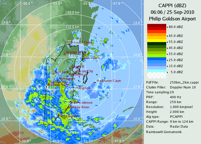
At midday, Matthew was very close to making landfall on the eastern tip Honduras and northern Nicaragua. The central pressure dropped to 998hPa.Its location at this point was 401miles ESE of Belize City and 386miles ESE of Dangriga town. This position was also about 402miles E’S of Punta Gorda town. The National Meteorological Service issued its first hydromet bulletin for onward transmission the National Emergency Management Organization (NEMO). This report detailed the forecast weather conditions for Belize and coastal waters. A small craft warning was issued with an advisory requesting all craft to seek safe harbour. Rainfall estimates range from 6 to 12inches for the country with maxima near 18inches for southern and central Belize. The risk of flooding in the south and low-lying coastal areas was also highlighted.Matthew spent the remainder of the evening heading across the mainland of northern Honduras. The second hydromet bulletin issued by the NMS (Belize) at 3:00pm(Local time) noted the increase in the radius of tropical storm force winds to 175miles.Maximum sustained winds had decreased to 45mph.At 6:00pm these winds increased to 50mph.The central pressure held steady at 998hPa into the following day (Sept.25th). The Belize government issued a tropical storm warning at 9:00pm for the coast of Belize. At midnight on Saturday the warning was defined for the coast of Belize south of Belize City. A tropical storm watch was now in force from Belize City north. The sixth hydromet bulletin issued by the NMS put tropical storm Matthew near lat.15.7ºN and long.86.3ºW or about156miles southeast by south (SE’S) of Dangriga and 169miles E’S of Punta Gorda town. The coastal region of the Stann Creek and Toledo districts were within the radius of tropical storm winds(see radar image below).
At 6:00am the center of tropical storm Matthew was near lat.15.8ºN and long.87.3ºW or about 85miles ESE of Monkey River town and about 102miles SE of Dangriga town. Maximum sustained winds had decreased to 45mph and the minimum central pressure had risen slightly (1000hPa).
Matthew’s land fall on the coast of Belize
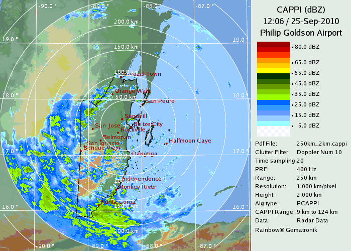
At 9:00am Saturday (Sept.25th) tropical storm Matthew was centred near lat. 16.2ºN and long.87.8ºW or about 45miles east of Monkey River Village in the Stann Creek district. This position was also about 61miles SE of Dangriga town and 68miles east north east (ENE) of Punta Gorda town. Matthew was heading west-northwest at 15mph with maximum sustained winds of 40mph.Tropical storm force winds extended out 140miles from the center. The storm made landfall in the next few hours near Monkey river town.
At midday the government of Belize issued the all clear and the tropical storm watch and warning for the coast of Belize were discontinued. The center of tropical depression Matthew at midday was located near lat.16.7ºN and long.88.6ºW or about 31miles southwest of Dangriga, 45miles north-northeast of Punta Gorda town and 61miles south-southwest of Belize City. Matthew continued to head west-northwest at 15mph.Maximum sustained winds had decreased to near 35mph.
Rainfall and Flooding
According to sources from NEMO flooding from the rains associated with TS Matthew was the greatest risk. The floods occurred in low-lying areas including portions of Belize City. The table below details the quantity of rainfall, which occurred across the country before, during and after the passage of tropical storm Matthew. The highest rainfall occurred in the west at Barton Creek with 191.2mm.Several network stations measured rainfall amounts ranging between 85 to 150mm during the two days (Sept.24-25th, 2010) when TS Matthew approached and crossed the country.Table of rainfall data (mm) for stations in Belize before, during and after TS Matthew
Date/Stn |
LIB |
RBV |
TWR |
PGIA |
LDA |
BCA |
BDY |
BTC |
HSY |
PMA |
MDX |
SVH |
BFL |
PGA |
Sept.23 |
2.7 |
1.8 |
8.7 |
0.1 |
29.5 |
8.5 |
0.0 |
3.6 |
8.3 |
27.9 |
9.9 |
13.2 |
N/A |
43.6 |
Sept.24 |
4.1 |
24.2 |
16.1 |
11.2 |
18.4 |
42.8 |
86.2 |
80.4 |
65.4 |
48.3 |
54.3 |
69.5 |
69.4 |
87.4 |
Sept.25 |
12.2 |
12.7 |
4.4 |
25.9 |
28.2 |
84.5 |
64.6 |
110.8 |
20.4 |
72.4 |
56.6 |
102.0 |
80.5 |
95.0 |
Sept.26 |
12.0 |
8.4 |
8.1 |
28.9 |
0.0 |
N/A |
0.0 |
8.8 |
1.2 |
7.6 |
2.4 |
11. |
14.0 |
64.3 |
Total |
16.3 |
36.9 |
20.5 |
37.1 |
46.6 |
127.3 |
150.8 |
191.2 |
85.8 |
120.7 |
110.9 |
171.5 |
149.9 |
182.4 |
N.B. totals calculated are for the two days(Sept.24th and 25th) when TS Matthew affected Belize.
Damages
NEMO sources indicate the greatest damage occurred in the south of the country where some damage occurred to portions of the rice crop. Flooding caused some damage. NEMO evacuated people from three villages in southern Belize as a precaution against flooding. Since the passage of Matthew occurred during the height of the weekend, many social and outdoor events were cancelled. There was no loss of life associated with the events surrounding tropical strom Matthew in Belize.
Remarks and Conclusion
A significant component in the functioning of the NMS revolves around efficient communication services. Electricity services can also impede the operation of the NMS although the service is equipped with a functional stand by generator. During the events associated with tropical strom Matthew, none of these services (communications provide by Belize Telemedia and power by Belize Electricity Ltd.) mal functioned. This meant the weather service was able perform all it functions to full capacity. The Belize Doppler radar provided tremendous support with its quality images detailing the approach of the storm towards Belize. In summary, the warning services provided by the NMS in conjunction with NEMO functioned well.Table of Chronological data for the life cycle of tropical depression/storm Matthew
Date |
Time |
Latitude (ºN) |
Longitude (ºW) |
Max. Winds (mph) |
Min.central pressure (hPa) |
Movement |
Sept.23rd |
12:00pm |
13.9 |
76.2 |
35 |
1007 |
WNW-15mph |
|
3:00pm |
14.0 |
76.9 |
40 |
1006 |
WNW-16 |
|
6:00pm |
14.2 |
77.7 |
40 |
1005 |
W-16 |
|
9:00pm |
14.0 |
78.4 |
45 |
1005 |
WNW-17 |
Sept.24th |
12:00am |
14.2 |
79.3 |
45 |
1005 |
W-17 |
|
3:00am |
14.3 |
79.8 |
50 |
1000 |
WNW-16 |
|
6:00am |
14.3 |
80.7 |
50 |
1000 |
W-16 |
|
9:00am |
14.4 |
82.2 |
50 |
1001 |
WNW-20 |
|
12:00pm |
14.6 |
83.0 |
50 |
998 |
W-18mph |
|
3:00pm |
14.7 |
83.7 |
45 |
998 |
WNW-15 |
|
6:00pm |
14.9 |
84.4 |
50 |
998 |
W-15mph |
|
9:00pm |
15.2 |
85.0 |
50 |
998 |
WNW-15 |
Sept.25th |
12:00am |
15.5 |
85.7 |
50 |
998 |
WNW-15 |
|
3:00am |
15.7 |
86.3 |
50 |
998 |
WNW-16 |
|
6:00am |
15.8 |
87.3 |
45 |
1000 |
WNW-16 |
|
9:00am |
16.2 |
87.8 |
40 |
1000 |
WNW-15 |
|
12:00pm |
16.7 |
88.6 |
35 |
1003 |
WNW-15 |
|
3:00pm |
17.4 |
89.4 |
35 |
1003 |
WNW-14 |
|
9:00pm |
17.0 |
91.0 |
35 |
1001 |
WNW-14 |
Sept.26th |
3:00am |
17.3 |
91.8 |
30 |
1003 |
WNW-10 |
|
9:00am |
17.4 |
92.9 |
25 |
1003 |
W-9 |
References:
Belize Meteorological Service hydromet bulletins.
Elliot, Dyon A. “T.Matthew left only water in its wake” The Reporter 3 Oct. 2010, page 21
Stewart, Stacy (2010-09-23) Special Discussion, National Hurricane Center, Miami, Florida.
Stewart, Stacy (2010-09-23) Tropical storm Matthew, National Hurricane Center, Miami, Florida.
Brown(2010-09-23) Tropical storm Matthew, National Hurricane Center, Miami, Florida
Beven(2010-09-24) Tropical storm Matthew, National Hurricane Center, Miami, Florida.
Avila,Lixion(2010-09-24) Tropical storm Matthew, National Hurricane Center, Miami, Florida.
Brennan(2010-09-24) Tropical storm Matthew, National Hurricane Center, Miami, Florida.